Английская Википедия:Champlain Canal
Шаблон:Short description Шаблон:Use mdy dates Шаблон:Infobox canal Шаблон:Infobox NRHP
The Champlain Canal is a Шаблон:Convert canal in New York that connects the Hudson River to the south end of Lake Champlain. It was simultaneously constructed with the Erie Canal for use by commercial vessels, fully opening in 1823. Today, it is mostly used by recreational boaters as part of the New York State Canal System and Lakes to Locks Passage.
Water for the highest portion comes from the Hudson River via the Glens Falls Feeder Canal, from above the drop at Glens Falls, New York.
History
An early proposal made in the 1790s by Marc Isambard Brunel for a Hudson River–Lake Champlain canal was not approved. Another proposal for the canal was made in 1812 and construction authorized in 1817. By 1818, Шаблон:Convert were completed, and in 1819 the canal was opened from Fort Edward to Lake Champlain. The canal was officially opened on September 10, 1823.[1] It was an immediate financial success, and carried substantial commercial traffic until the 1970s.Шаблон:Citation needed
In 1903, New York authorized the expansion of the Champlain Canal—along with the Erie, Oswego, and Cayuga–Seneca Canals—into the "New York State Barge Canal."[2] The project broke ground in 1905 and was completed in 1918.[3] The "Barge Canal" name fell out of use in 1992.
The abandoned Lake Champlain Seaway proposal would have upgraded the Champlain Canal into a ship canal, easing marine transport between New York City and Montreal.
Route
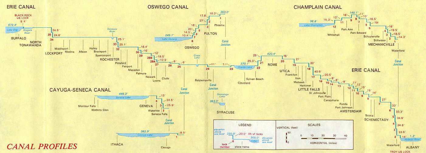
The Champlain Canal's southern end is about Шаблон:Convert north of the locks at the Troy Federal Dam, at the point where the Erie Canal splits from the Hudson River. The Hudson River is designated as part of the canal proceeding north for approximately Шаблон:Convert, with six locks providing navigation around dams, until it reaches lock C-7 in Fort Edward, New York. At this point, the canal diverges from the river and follows a constructed channel for approximately Шаблон:Convert, with five additional locks, bringing the canal to the southern end of Lake Champlain at Whitehall, New York.
The elevation on the Hudson River portion increases from Шаблон:Convert above sea level at the southern end, on the northern end of the locks at the Troy Federal Dam, to about Шаблон:Convert above sea level at lock C-7, where the canal leaves the Hudson River. The elevation of the constructed portion reaches a peak of Шаблон:Convert above sea level between locks C-9 and C-11, then declines to the level of Lake Champlain, between Шаблон:Convert above sea level, at Whitehall.[4] By traveling the length of Lake Champlain, boaters can access the Richelieu River and Chambly Canal, which connect Lake Champlain to the Saint Lawrence River.
Locks
The following list of locks is provided for the current canal, from south to north. There are a total of 11 locks on the Champlain Canal.
All locks on the New York State Canal System are single-chamber; the dimensions are Шаблон:Convert long and Шаблон:Convert wide with a minimum Шаблон:Convert depth of water over the miter sills at the upstream gates upon lift. They can accommodate a vessel up to Шаблон:Convert long and Шаблон:Convert wide.[5][6][7] Overall sidewall height will vary by lock, ranging between Шаблон:Convert depending on the lift and navigable stages.[8]
There is no Lock C10 on the Champlain Canal. The Troy Federal Lock, located just north of Troy, New York, is not part of the New York State Canal System proper; it is operated by the United States Army Corps of Engineers.[5] The Champlain Canal officially begins at the confluence of the Hudson and Mohawk rivers at Waterford, New York.
Distance is based on position markers from an interactive canal map provided online by the New York State Canal Corporation and may not exactly match specifications on signs posted along the canal. Mean surface elevations are comprised from a combination of older canal profiles and history books as well as specifications on signs posted along the canal.[5][9][10] The margin of error should normally be within Шаблон:Convert.
All surface elevations are approximate.
* Denotes Federal managed locks.
Lake Champlain has a mean surface elevation ranging between Шаблон:Convert.
References
External links
- Information and Boater's Guide to the New York State Canal System
- History of the Canal System of the State of New York—Champlain Canal
- New York State Canals—Map of the Champlain Canal
- Champlain Canal Net—History and Photographs
- Historic Glens Falls Feeder Canal
- Шаблон:HABS
- Historic American Engineering Record (HAER) documentation:
- Шаблон:HAER
- Шаблон:HAER (replaced)
- Шаблон:HAER
- Шаблон:HAER
Шаблон:New York State Canal System Шаблон:National Register of Historic Places in New York Шаблон:Hudson River Шаблон:Authority control
- ↑ Шаблон:Cite book
- ↑ Шаблон:Cite book
- ↑ Шаблон:Cite book
- ↑ Шаблон:Cite web
- ↑ 5,0 5,1 5,2 New York State Canal Corporation - Canal Map, New York State Canals, Retrieved Jan. 26, 2015.
- ↑ New York State Canal Corporation - Frequently Asked Questions, Retrieved Jan. 26, 2015.
- ↑ The Erie Canal - Locks, Retrieved Jan, 26, 2015.
- ↑ The Erie Canal, History of the Barge Canal of New York State by Noble E. Whitford, 1921, Chapter 23, Retrieved Jan. 28, 2015.
- ↑ Wilfred H. Schoff, The New York State Barge Canal, 1915, American Geographical Society, Vol. 47, No. 7, page 498, Retrieved Jan. 26, 2015.
- ↑ The Erie Canal - Canal Profiles, Retrieved Jan. 6, 2015.
- Английская Википедия
- Страницы с неработающими файловыми ссылками
- Canals on the National Register of Historic Places in New York (state)
- Canals in New York (state)
- Historic American Buildings Survey in New York (state)
- Historic American Engineering Record in New York (state)
- Historic districts on the National Register of Historic Places in New York (state)
- Bridges in Rensselaer County, New York
- Transportation buildings and structures in Saratoga County, New York
- Transportation buildings and structures in Washington County, New York
- Tributaries of the Hudson River
- Canals opened in 1823
- National Register of Historic Places in Rensselaer County, New York
- National Register of Historic Places in Saratoga County, New York
- National Register of Historic Places in Washington County, New York
- 1823 establishments in New York (state)
- Страницы, где используется шаблон "Навигационная таблица/Телепорт"
- Страницы с телепортом
- Википедия
- Статья из Википедии
- Статья из Английской Википедии