Шаблон:Short description
Шаблон:Infobox mountain
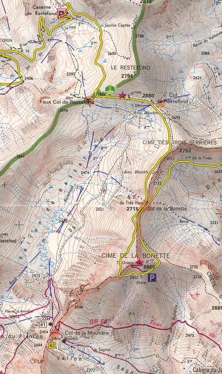
Cime de la Bonette (el. Шаблон:Convert) is a mountain in the French Alps, near the border with Italy. It is situated within the Mercantour National Park on the border of the departments of Alpes-Maritimes and Alpes-de-Haute-Provence, between the Ubaye Valley and the valley of the Tinée River.
"Cime" means "summit" in French.
The summit is surrounded by road from the Col de la Bonette, which reaches Шаблон:Convert, and is the second highest paved through route in the Alps. It is also the highest point reached by the Tour de France.[1]
See also
References
Шаблон:Reflist
External links
| Партнерские ресурсы |
|---|
| Криптовалюты |
|
|---|
| Магазины |
|
|---|
| Хостинг |
|
|---|
| Разное |
- Викиум - Онлайн-тренажер для мозга
- Like Центр - Центр поддержки и развития предпринимательства.
- Gamersbay - лучший магазин по бустингу для World of Warcraft.
- Ноотропы OmniMind N°1 - Усиливает мозговую активность. Повышает мотивацию. Улучшает память.
- Санкт-Петербургская школа телевидения - это федеральная сеть образовательных центров, которая имеет филиалы в 37 городах России.
- Lingualeo.com — интерактивный онлайн-сервис для изучения и практики английского языка в увлекательной игровой форме.
- Junyschool (Джунискул) – международная школа программирования и дизайна для детей и подростков от 5 до 17 лет, где ученики осваивают компьютерную грамотность, развивают алгоритмическое и креативное мышление, изучают основы программирования и компьютерной графики, создают собственные проекты: игры, сайты, программы, приложения, анимации, 3D-модели, монтируют видео.
- Умназия - Интерактивные онлайн-курсы и тренажеры для развития мышления детей 6-13 лет
- SkillBox - это один из лидеров российского рынка онлайн-образования. Среди партнеров Skillbox ведущий разработчик сервисного дизайна AIC, медиа-компания Yoola, первое и самое крупное русскоязычное аналитическое агентство Tagline, онлайн-школа дизайна и иллюстрации Bang! Bang! Education, оператор PR-рынка PACO, студия рисования Draw&Go, агентство performance-маркетинга Ingate, scrum-студия Sibirix, имидж-лаборатория Персона.
- «Нетология» — это университет по подготовке и дополнительному обучению специалистов в области интернет-маркетинга, управления проектами и продуктами, дизайна, Data Science и разработки. В рамках Нетологии студенты получают ценные теоретические знания от лучших экспертов Рунета, выполняют практические задания на отработку полученных навыков, общаются с экспертами и единомышленниками. Познакомиться со всеми продуктами подробнее можно на сайте https://netology.ru, линейка курсов и профессий постоянно обновляется.
- StudyBay Brazil – это онлайн биржа для португалоговорящих студентов и авторов! Студент получает уникальную работу любого уровня сложности и больше свободного времени, в то время как у автора появляется дополнительный заработок и бесценный опыт.
- Автор24 — самая большая в России площадка по написанию учебных работ: контрольные и курсовые работы, дипломы, рефераты, решение задач, отчеты по практике, а так же любой другой вид работы. Сервис сотрудничает с более 70 000 авторов. Более 1 000 000 работ уже выполнено.
- StudyBay – это онлайн биржа для англоязычных студентов и авторов! Студент получает уникальную работу любого уровня сложности и больше свободного времени, в то время как у автора появляется дополнительный заработок и бесценный опыт.
|
|---|