Шаблон:For
Шаблон:Infobox airportDalhart Municipal Airport Шаблон:Airport codes is in unincorporated Hartley County, Texas,[1] three miles (5 km) southwest of Dalhart, Texas,[2] a city straddling the border of Dallam and Hartley counties in the northwest corner of the Texas Panhandle.[3]
The airport sees no airlines.
Facilities
The airport covers Шаблон:Convert and has two asphalt runways: 3/21 is 5,440 x 75 ft (1,658 x 23 m) and 17/35 is 6,400 x 75 ft (1,951 x 23 m).[2]
In the year ending September 16, 2021, the airport had 7,650 aircraft operations, average 21 per day: 65% local general aviation, 33% transient general aviation, and 2% military. 40 aircraft were based at this airport: 33 single-engine, 5 multi-engine, 1 helicopter, and 1 glider.[2]
History
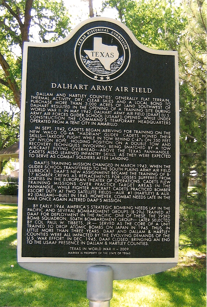
The airport was built by the Army and opened in May 1942 as Dalhart Army Airfield. Initially assigned to Army Air Forces Glider command, while under construction the command's temporary headquarters operated from a tent city in Amarillo.[4]
Dalhart AAF closed in December 1945; the property went to the city. Several remaining buildings have been used as the Dalhart municipal airport.[4]
See also
References
Шаблон:Reflist
External links
Шаблон:US-airport-ga
Шаблон:Authority control
Шаблон:Texas-airport-stub
Шаблон:Texas-struct-stub
| Партнерские ресурсы |
|---|
| Криптовалюты |
|
|---|
| Магазины |
|
|---|
| Хостинг |
|
|---|
| Разное |
- Викиум - Онлайн-тренажер для мозга
- Like Центр - Центр поддержки и развития предпринимательства.
- Gamersbay - лучший магазин по бустингу для World of Warcraft.
- Ноотропы OmniMind N°1 - Усиливает мозговую активность. Повышает мотивацию. Улучшает память.
- Санкт-Петербургская школа телевидения - это федеральная сеть образовательных центров, которая имеет филиалы в 37 городах России.
- Lingualeo.com — интерактивный онлайн-сервис для изучения и практики английского языка в увлекательной игровой форме.
- Junyschool (Джунискул) – международная школа программирования и дизайна для детей и подростков от 5 до 17 лет, где ученики осваивают компьютерную грамотность, развивают алгоритмическое и креативное мышление, изучают основы программирования и компьютерной графики, создают собственные проекты: игры, сайты, программы, приложения, анимации, 3D-модели, монтируют видео.
- Умназия - Интерактивные онлайн-курсы и тренажеры для развития мышления детей 6-13 лет
- SkillBox - это один из лидеров российского рынка онлайн-образования. Среди партнеров Skillbox ведущий разработчик сервисного дизайна AIC, медиа-компания Yoola, первое и самое крупное русскоязычное аналитическое агентство Tagline, онлайн-школа дизайна и иллюстрации Bang! Bang! Education, оператор PR-рынка PACO, студия рисования Draw&Go, агентство performance-маркетинга Ingate, scrum-студия Sibirix, имидж-лаборатория Персона.
- «Нетология» — это университет по подготовке и дополнительному обучению специалистов в области интернет-маркетинга, управления проектами и продуктами, дизайна, Data Science и разработки. В рамках Нетологии студенты получают ценные теоретические знания от лучших экспертов Рунета, выполняют практические задания на отработку полученных навыков, общаются с экспертами и единомышленниками. Познакомиться со всеми продуктами подробнее можно на сайте https://netology.ru, линейка курсов и профессий постоянно обновляется.
- StudyBay Brazil – это онлайн биржа для португалоговорящих студентов и авторов! Студент получает уникальную работу любого уровня сложности и больше свободного времени, в то время как у автора появляется дополнительный заработок и бесценный опыт.
- Автор24 — самая большая в России площадка по написанию учебных работ: контрольные и курсовые работы, дипломы, рефераты, решение задач, отчеты по практике, а так же любой другой вид работы. Сервис сотрудничает с более 70 000 авторов. Более 1 000 000 работ уже выполнено.
- StudyBay – это онлайн биржа для англоязычных студентов и авторов! Студент получает уникальную работу любого уровня сложности и больше свободного времени, в то время как у автора появляется дополнительный заработок и бесценный опыт.
|
|---|